Snapshot (who each is for)
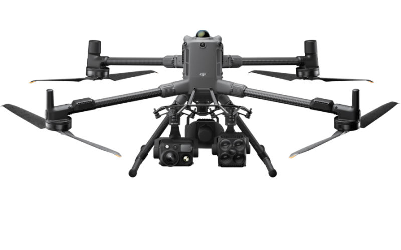
- Matrice 400 (M400): Heavy-lift, multi-payload flagship for complex, long-range work (utilities, public safety, offshore, survey with LiDAR/full-frame). 59-min max flight, IP55, and power-line-level obstacle sensing.
- Matrice 4E (M4E): Compact, integrated tri-camera platform optimized for mapping/survey and site documentation with a 4/3″ 20 MP wide camera + mechanical shutter and 0.5 s photo interval.
Airframe, durability & operating envelope
- Weather rating & temps
- M400: IP55, operating –20 °C to 50 °C. Built for foul weather and wide temp swings.
- M4E: No official IP rating; operating –10 °C to 40 °C; 12 m/s max wind during T/O & landing.
- Mass & payload
- M400: Max takeoff 15.8 kg; max payload 6 kg. Multiple gimbal mount options (single/dual/triple).
- M4E: Compact class; max payload 200 g via E-Port/E-Port Lite for small add-ons (e.g., beacons).
Sensing & flight safety
- Dji Matrice 400: Fusion sensing with omnidirectional binocular vision + rotating LiDAR (360°) + upward LiDAR + six-direction mmWave radar + 3D IR bottom—designed for line-inspection-grade obstacle perception.

- DJI Matrie 4E: Omnidirectional binocular vision complemented by a 3D IR bottom sensor; robust for enterprise operations but not LiDAR/mmWave-equipped.

Imaging & mapping workflows
- M4E (integrated tri-camera):
- Wide: 4/3″ 20 MP, mechanical shutter 1/2000 s, electronic to 1/8000 s, 24 mm eq., f/2.8–f/11. 0.5 s minimum photo interval; RAW (DNG) support.
- Medium-tele: 48 MP (1/1.3″). Tele: 48 MP (1/1.5″) with 112× hybrid (16× digital).
- Smart 3D Capture and multi-angle ortho/oblique modes speed route creation and quick rough models on the RC.
- M400 (modular payloads):
- Works with Zenmuse H30/H30T (inspection/zoom), L2 (survey-grade LiDAR), and P1 (full-frame mapping) among others—so you can tailor imaging from ultra-tele inspections to cm-level survey deliverables.
Performance & link
- M400: Max flight time 59 min (53 min hover with H30T), 25 m/s top speed, O4 Enterprise Enhanced link up to 40 km (FCC) / 20 km (CE).
- M4E: Max flight time 49 min (42 min hover), 21 m/s top speed, O4 Enterprise up to 25 km (FCC) / 12 km (CE).
Ecosystem & expandability
- M400: E-Port V2 ×4 (expandable to 7 payloads via hub), supports PSDK, X-Port/Skyport adaptors, Manifold 3 onboard computing (up to 100 TOPS) for on-aircraft AI and autonomy.
- M4E: E-Port + E-Port Lite for light accessories (not hot-swappable); integrated gimbal is not swappable.
Remote & autonomous ops (Dock & Cloud)
- Dock compatibility
- M4E: Supported by DJI Dock 3 (alongside 4T/4D variants).
- M400: No native DJI dock; relies on partner tether/dock solutions.
- Cloud & control: Both platforms integrate with DJI FlightHub 2 and the Cloud API for fleet management and data workflows (RTK options via D-RTK 3).
What it’s like in real missions
Power & utilities (live lines, substations, corridors):
If you need maximum sensor fusion against wires/towers, multi-payload stacks (e.g., H30T + L2), and all-weather reliability, the M400 is the safer bet. The rotating LiDAR + mmWave radar stack reduces surprises in cluttered, reflective, or low-light environments.
Aerial mapping & construction monitoring:
If your main output is orthos/DSM/DTM/3D with frequent flights, M4E is brilliant out-of-the-box: mechanical shutter, high cadence (0.5 s), and built-in multi-angle capture. For survey-grade LiDAR or full-frame photogrammetry, the M400 + L2/P1 combo scales farther.
BVLOS & long-range inspection:
M400 offers 59 min endurance, 40 km/20 km link budgets (regulatory permitting), IP55, and –20 °C to 50 °C envelope—great for extended corridors or offshore where margins matter.
Docked autonomy / rapid redeploy sites:
If you’re standardizing on DJI Dock 3, M4E is the integrated path today. M400 requires partner dock/tether solutions.
Head-to-head spec highlights
| Category | Matrice 400 | Matrice 4E |
|---|---|---|
| Max flight time | 59 min (53 min hover) | 49 min (42 min hover) |
| Top speed | 25 m/s | 21 m/s |
| Link (FCC / CE) | 40 km / 20 km | 25 km / 12 km |
| Operating temp | –20 °C to 50 °C | –10 °C to 40 °C |
| Weather rating | IP55 | No official IP rating |
| Max payload | 6 kg (multi-gimbal) | 200 g (accessories) |
| Obstacle sensing | Vision + rotating LiDAR + mmWave radar + 3D IR | Vision + 3D IR (no LiDAR/mmWave) |
| Cameras | Modular (H30/H30T, L2, P1, etc.) | Integrated tri-camera (4/3″ wide w/ mechanical shutter, 48 MP med-tele & tele) |
| Dock | Partner docks only (tether option) | DJI Dock 3 |
| Onboard compute | Manifold 3 (up to 100 TOPS) | — |
Best one
- Choose Matrice 400 when you need a rugged, scalable, multi-sensor platform with the best obstacle-sensing stack, heaviest payloads, and longest endurance—ideal for complex inspections, corridor BVLOS, and survey with LiDAR or full-frame mapping.
- Choose Matrice 4E when you want a portable, mapping-optimized system that flies often and fast with mechanical-shutter ortho/oblique capture and minimal setup—perfect for construction, earthworks, asset documentation, and quick-turn geospatial packages.